2009
25
lip
Headlands
Islandia, Hrafnabjorg
Przejechano 3463 km
Today was a peninsula day. We drove all the way from Asbyrgi to Vopnafjordur along the coast. The first town on our way, Kopasker, was damaged by an earthquake some 30 years ago but I didn't see any signs of the disaster or I couldn't recognize them. However there's a funny and interesting collection of scarecrows (made by a local artist) by the main road and it's impossible to miss them.
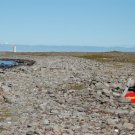
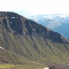
There are many minor roads that will take you to the coast. Do this at least once because there are beautiful cliffs and rocks here. Besides, I had an opportunity to see and touch the famous Icelandic sand which is completely black! It must be harder than normal one (Baltic, for example) or it's formed everyday by the tide because the beach is flat.
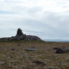
After next 40 or 50km, we reached Hraunhofnartangi - the northernmost point in Iceland. It's very modest (like the most of interesting and beautiful places here), with a lighthouse and a grave of some saga hero (there is no information about the hero there, I learned it from a guidebook, but it's hard to miss it). The cape was where we really met arctic terns. They're so aggressive that if I wouldn't hadn't had a hat, I'd have been in trouble. I probably walked too close to their nests but going away didn't help (or maybe they had their nests everywhere). They screamed loudly and they kept on flying just above my head. People say holding a stick high in the air is a good way to get rid of them. But... try to find a stick in Iceland!
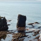
I wanted to get to the end of goose-shaped Langanes peninsula but 15 or 20km before it I realized it's too late and we had to turn back. Anyway, there was a reward for the effort: I finally got a chance to see puffins! They sat on a cliff along with penguin-like birds and bad, ugly ones who hunted for those little cuties! It must have been a good place for bird watchers as there was one guy with special equipment, sitting on the edge and probably waiting for the birds to pose.
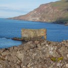
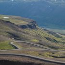
If you come to this region, you should definitely drive the picturesque route 917. It goes through Smjorfjell which is translated into English as "The butter mountains". Such a road going straight through mountains is rare in Iceland, they probably always have a few kilometers of flat terrain to build a road. Eventually we arrived in a small campsite by a big river (Jokulsa a Bru). A quiet, peaceful place and the only campsite where I didn't have to pay for showers - they were free. 


There are many minor roads that will take you to the coast. Do this at least once because there are beautiful cliffs and rocks here. Besides, I had an opportunity to see and touch the famous Icelandic sand which is completely black! It must be harder than normal one (Baltic, for example) or it's formed everyday by the tide because the beach is flat.
After next 40 or 50km, we reached Hraunhofnartangi - the northernmost point in Iceland. It's very modest (like the most of interesting and beautiful places here), with a lighthouse and a grave of some saga hero (there is no information about the hero there, I learned it from a guidebook, but it's hard to miss it). The cape was where we really met arctic terns. They're so aggressive that if I wouldn't hadn't had a hat, I'd have been in trouble. I probably walked too close to their nests but going away didn't help (or maybe they had their nests everywhere). They screamed loudly and they kept on flying just above my head. People say holding a stick high in the air is a good way to get rid of them. But... try to find a stick in Iceland!
I wanted to get to the end of goose-shaped Langanes peninsula but 15 or 20km before it I realized it's too late and we had to turn back. Anyway, there was a reward for the effort: I finally got a chance to see puffins! They sat on a cliff along with penguin-like birds and bad, ugly ones who hunted for those little cuties! It must have been a good place for bird watchers as there was one guy with special equipment, sitting on the edge and probably waiting for the birds to pose.
If you come to this region, you should definitely drive the picturesque route 917. It goes through Smjorfjell which is translated into English as "The butter mountains". Such a road going straight through mountains is rare in Iceland, they probably always have a few kilometers of flat terrain to build a road. Eventually we arrived in a small campsite by a big river (Jokulsa a Bru). A quiet, peaceful place and the only campsite where I didn't have to pay for showers - they were free.
Zdjęcia (6)
Komentarze (2)

 Antoine Cassar - 2011-10-27 18:57
Thank you for this extremely pleasant and useful information on the Langanes peninsula, which I hope to visit soon. Where there many geese around?
Kind regards,
Antoine Cassar
http://antoinecassar.info
Kind regards,
Antoine Cassar
http://antoinecassar.info

 alkamid - 2011-10-27 23:58
Salut Antoine,
I remember sheep from the cliffs near Kopasker and obviously ubiquitous arctic terns, but I don't think there were many geese.
Cheers,
alkamid
I remember sheep from the cliffs near Kopasker and obviously ubiquitous arctic terns, but I don't think there were many geese.
Cheers,
alkamid