2009
20
lip
Hiking, day 2
Islandia, Álftavatn
Przejechano 2853 km
I've read a few people writing that the best and most beautiful views are those from Landmannalaugar and within 20 minutes hiking from it. I disagree. The second part of the Laugavegur (H... - Alftavatn) offers you three breathtaking (and different) sceneries.
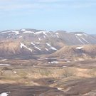
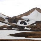
The first one you can see from the hut: little hills that look black and white because of the snow and a dark ground that consists of many small rocks.
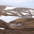
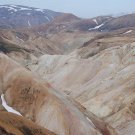
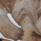
The next one is the one I've seen in pictures before: great and regular slopes resembling a mountain desert. Here and there hot springs (or holes with hot vapor going out of them). The colors here are so amazing. You can even spot a reddish spring!
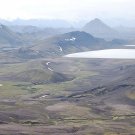
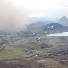
The lasdt one waits for you just before the river crossing and it won't leave you until Alftavatn. On the left Myrdasjokul is visible and in front of you a green scenery with regular cones (are those volcenoes?) and the lake that marks your destination. When we saw it, a large dark cloud was moving from Myrdasjokul to the west. We were confused. Was it a small volcano eruption? Or a rock avalanche that pushed the dust up? It looked frightening but when we reached Alftavatn it was gone and we learned that such sandstorms are not rare in Iceland and they're caused by strong winds near glaciers.
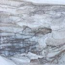
There are two "side trips" available from the trail. The first one goes west west from the hut and it finishes with great ice caves (I'll upload some photos as soon as I find a good Internet connection). Worth seeing only if you have water resistant boots because the most of the trail goes through the snow. I feel I didn't see all of the caves as there were a few trail marks ahead so maybe it's a good idea to follow them.
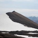
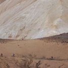
Another one is to climb a mountain somewhere in the middle of the distance (you will see a path going up, it's hard to miss it). For ten minutes I had to climb a very steep slope but the reward was worth the effort: I got a clear view in all directions. Bring your camera or focus on memorizing it. Astonishing. I was there when I saw a few people on BIKES. How to hell are one supposed to cycle this trail?! Bikers, you gained my respect, you're the hard core ones.
Well, I must admit that I did something extreme, too: I swam in Alftavatn, which is a lake connected with glacier rivers. Moreover, it's very shallow so I had to walk 50-70 meters (so cooold) until the water was deep enough to swim in it (that means it was a bit deeper than 1 meter). A thrilling experience.
If you are neither water nor cold lover, I recommend taking your shoes off and walking on moss near the place where the river flows into a lake. Very relaxing for your feet after a long hike... 


The first one you can see from the hut: little hills that look black and white because of the snow and a dark ground that consists of many small rocks.
The next one is the one I've seen in pictures before: great and regular slopes resembling a mountain desert. Here and there hot springs (or holes with hot vapor going out of them). The colors here are so amazing. You can even spot a reddish spring!
The lasdt one waits for you just before the river crossing and it won't leave you until Alftavatn. On the left Myrdasjokul is visible and in front of you a green scenery with regular cones (are those volcenoes?) and the lake that marks your destination. When we saw it, a large dark cloud was moving from Myrdasjokul to the west. We were confused. Was it a small volcano eruption? Or a rock avalanche that pushed the dust up? It looked frightening but when we reached Alftavatn it was gone and we learned that such sandstorms are not rare in Iceland and they're caused by strong winds near glaciers.
There are two "side trips" available from the trail. The first one goes west west from the hut and it finishes with great ice caves (I'll upload some photos as soon as I find a good Internet connection). Worth seeing only if you have water resistant boots because the most of the trail goes through the snow. I feel I didn't see all of the caves as there were a few trail marks ahead so maybe it's a good idea to follow them.
Another one is to climb a mountain somewhere in the middle of the distance (you will see a path going up, it's hard to miss it). For ten minutes I had to climb a very steep slope but the reward was worth the effort: I got a clear view in all directions. Bring your camera or focus on memorizing it. Astonishing. I was there when I saw a few people on BIKES. How to hell are one supposed to cycle this trail?! Bikers, you gained my respect, you're the hard core ones.
Well, I must admit that I did something extreme, too: I swam in Alftavatn, which is a lake connected with glacier rivers. Moreover, it's very shallow so I had to walk 50-70 meters (so cooold) until the water was deep enough to swim in it (that means it was a bit deeper than 1 meter). A thrilling experience.
If you are neither water nor cold lover, I recommend taking your shoes off and walking on moss near the place where the river flows into a lake. Very relaxing for your feet after a long hike...
Zdjęcia (10)
Komentarze (0)